Posts Tagged Grand Staircase-Escalante National Monument
Fabulous Day at Capitol Reef Natl Park
Burr Trail Switchbacks into Waterpocket Fold
I added Capitol Reef to our Utah itinerary only because it’s so close to Arches and Canyonlands but it has turned out to be the surprise star of our trip. It combines all the colors, shapes and grandeur of Arches, Canyonlands, Bryce and Sedona, AZ to boot. Our day began driving from Torrey to Boulder via scenic byway Route 12 passing over Boulder Mountain at just above 9,600 feet. We passed through a brief snow squall but most of the drive featured wonderful vistas of parts of Capitol Reef and the Grand Staircase Escalante National Monument.
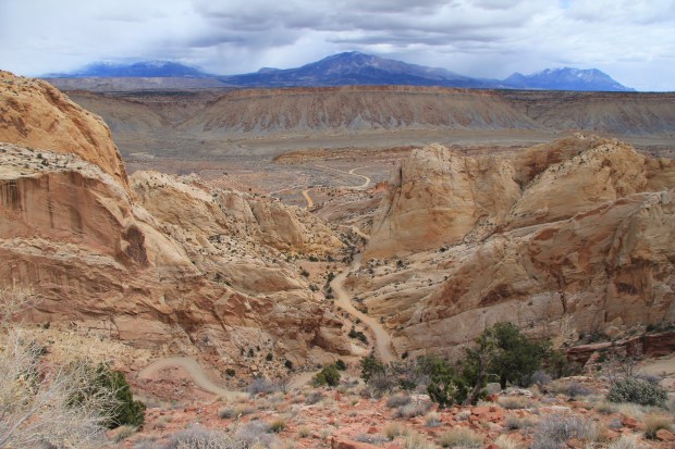
After a brief stop at the Anasazi State Park Museum we descended through the stunning walls of the Grand Staircase via the Burr Trail Road. A brief rain shower only intensified the amazing colors and patterns of the canyon walls. Re-entering Capitol Reef, the paved road ended and we bounced along the next 35 miles on the washboard Notom-Bullfrog Road with its endless vistas of the Waterpocket Fold and Henry Mountains.
![]() Here are some photos of the Burr Trail Road/Waterpocket Fold portion of the trip.
Here are some photos of the Burr Trail Road/Waterpocket Fold portion of the trip.
Returning to the Capitol Reef visitors’ center we spent over two hours doing the ten-mile Scenic Drive taking in still more mind-numbing views of the ever-changing reef colors and textures. Side trips via unpaved roads into Grand Wash and Capitol Gorge offered up perhaps the most grand views of the day. After dinner, as we sped back to our motel room we were treated to still another amazing sunset, as has been the case nearly every day of our trip.
Phoenix to Ogden, UT – 698 miles
Today was the first of our two-day journey home following the same route we took returning from Sedona in 2011. Except this time it’s the middle of winter. The first 400 miles to Long Valley Junction were uneventful with clear skies, dry roads and little traffic. Once again in northern Utah we got a glimpse of the incredible Vermilion Cliffs escarpments off Route 89 south of Page, UT. This little niche of the U.S. is just so fascinating. Looking to the west from the highway you know the eastern end of the Grand Canyon is just 70 or so miles away, Bryce and Zion lie just about 100 miles north, and the road passes right between the Vermilion Cliffs and Grand Staircase-Escalante National Monuments. It’s a geologic wonderland of every imaginable shape. As I had done for the outgoing trip, I checked the weather forecast for cities along the way and everything looked great. I forgot that that little 40-mile section of Route 14 between Long Valley Junction and Cedar City is a major mountain pass with elevations around 9,000 feet just south of Cedar Breaks National Monument. So we did have to navigate about half an hour of snow but the road surface was mostly well-cleared or sanded. Once through the snow squall, we began the descent toward Cedar City with absolutely stupendous views of the surrounding rock formations and valleys shrouded in fresh snow. It was breathtaking. Photos (19)…

